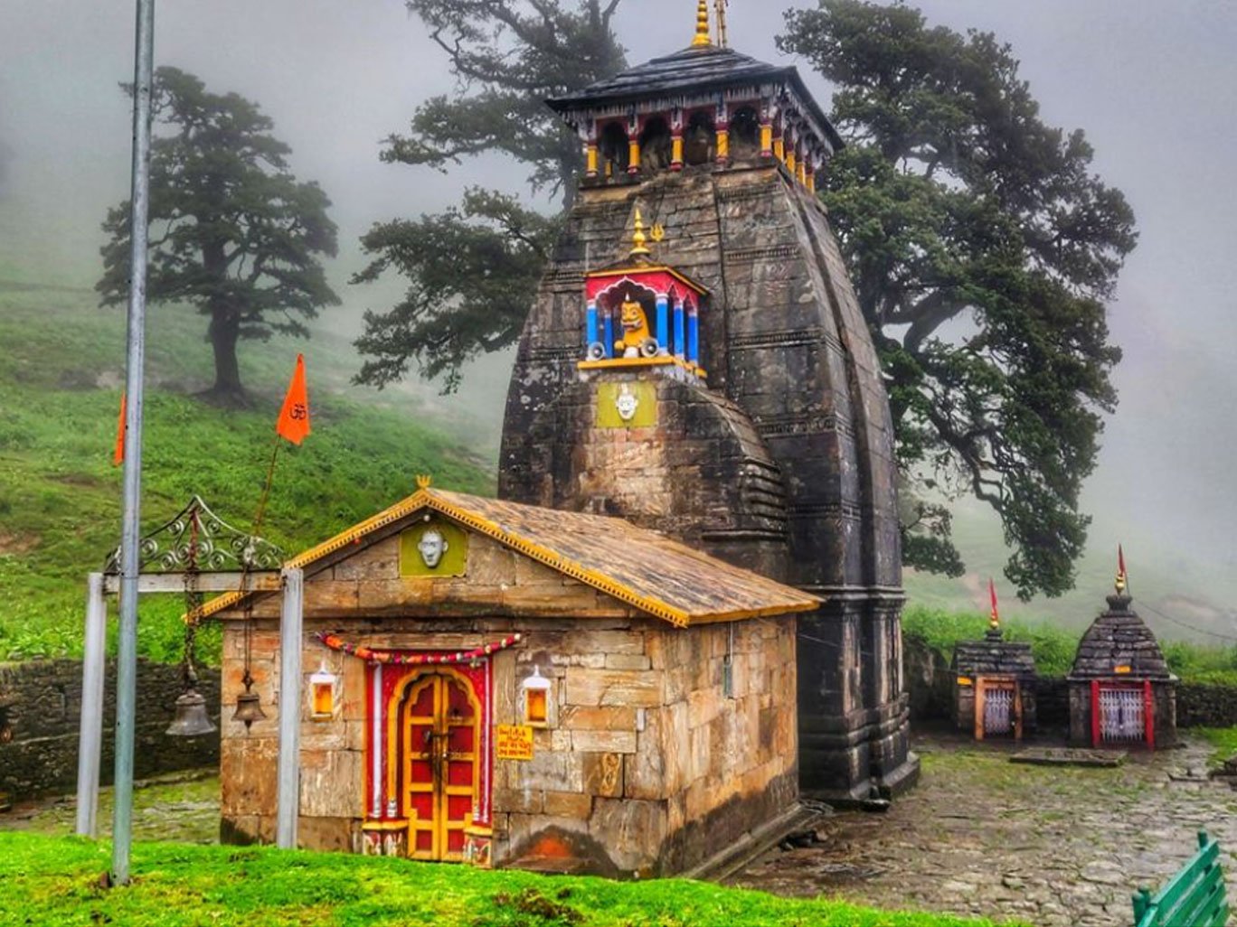
Mansuna Village is a small Himalayan settlement in Ukhimath Sub-district of Rudraprayag district, Uttarakhand, and an important geographical reference point for travellers heading toward the Madhyamaheshwar region. Although Mansuna is often mentioned online mainly because of its association with Madhyamaheshwar Temple, the village itself deserves to be understood as a separate destination with its own administrative identity, landscape, local life and travel significance.
The official Census records Mansuna under village code 042124, in Ukhimath Sub-district and Ukhimath development block of Rudraprayag district. Census 2011 recorded 888 residents living in 189 households, including 418 males and 470 females. The village is also associated with PIN code 246469.
For travellers, Mansuna is particularly relevant because the road network from Ukhimath toward the Madhyamaheshwar region passes through the Mansuna-Ransi corridor. A geological assessment published by Uttarakhand's Disaster Mitigation and Management Centre specifically identifies the Okhimath-Mansuna-Ransi link road when describing access to villages in the Madhyamaheshwar Ganga valley.
There is, however, an important distinction to make before planning a trip: Mansuna Village should not simply be treated as another name for the Madhyamaheshwar Trek. The village is the subject of this guide; Madhyamaheshwar Temple and its trekking route are separate search topics. Uttarakhand Tourism identifies Ransi as a base for the Madhyamaheshwar trek and identifies Uniana as the place from which the trek begins in its route information.
About Mansuna Village
Mansuna is a rural Himalayan village in Rudraprayag district of Uttarakhand, administratively associated with Ukhimath Sub-district and Ukhimath block.
The village is not a large commercial tourist centre. That distinction is important. Travellers looking for a fully developed destination with extensive hotels, restaurants, shops and transport options should use larger nearby settlements such as Ukhimath as their service base.
Mansuna is better understood as part of the mountain settlement network connecting Ukhimath with the Madhyamaheshwar region.
The Census 2011 database identifies Mansuna as a village within the Ukhimath administrative area and gives it the unique Census village code 042124.
Its geographical importance is greater than its size suggests. The Mansuna-Ransi road corridor provides access toward the villages and trekking landscape associated with Madhyamaheshwar. Government geological documentation also records access to Gaundar through the Okhimath-Mansuna-Ransi link road.
For someone travelling through this part of Garhwal, Mansuna therefore represents more than a pin on a map. It is part of the transition from the relatively accessible Ukhimath area toward the increasingly remote mountain settlements and trekking routes farther into the valley.
Where Is Mansuna Village?
Mansuna Village is located in Ukhimath Sub-district, Rudraprayag district, Uttarakhand, India.
Its administrative location can be summarised as:
Detail | Information |
|---|---|
Village | Mansuna |
Sub-district / Tehsil | Ukhimath |
Development Block | Ukhimath |
District | Rudraprayag |
State | Uttarakhand |
PIN Code | 246469 |
Census Village Code | 042124 |
Gram Panchayat | Mansuna |
Census Year | 2011 |
The official Census catalogue places Mansuna immediately within the sequence of villages belonging to the Ukhimath administrative area, including nearby entries such as Kunjalpur, Biroli and Burua.
Mansuna is also relatively close to Ukhimath. Census-derived village records put the sub-district headquarters at approximately 8 km from Mansuna, while road-distance sources commonly place the driving distance around 7 km. Actual road distance can vary according to the route and starting point used.
Mansuna Village Map
For navigation, travellers should use a current digital map immediately before departure rather than relying on an old static map.
Mountain roads can change because of landslides, road widening, drainage work, weather damage and temporary closures. A map showing a road does not necessarily mean that the road is currently open or suitable for every vehicle.
The most useful map sequence for trip planning is:
Rudraprayag → Ukhimath → Mansuna → Ransi / Madhyamaheshwar region
Do not confuse Mansuna with the high-altitude temple area simply because many travel websites use “Mansuna Village” when describing Madhyamaheshwar Temple.
Mansuna Village at a Glance
Feature | Details |
|---|---|
Location | Ukhimath, Rudraprayag, Uttarakhand |
Census code | 042124 |
Census population | 888 |
Census households | 189 |
Male population | 418 |
Female population | 470 |
Sex ratio | Approximately 1,124 females per 1,000 males |
PIN | 246469 |
Nearest administrative headquarters | Ukhimath |
District headquarters reference | Rudraprayag |
Village identity | Rural Himalayan settlement |
Madhyamaheshwar connection | Important road-corridor reference |
Main travel character | Village, mountain landscape and access corridor |
The population, household and demographic figures above are Census 2011 figures, not a current 2026 population estimate. Third-party websites currently publish conflicting population projections, and there is no reason to present an unofficial projection as the current official population.
Mansuna Village Population
According to Census 2011 data, Mansuna had a population of 888 people living in 189 households.
The population consisted of:
418 males
470 females
131 children aged 0–6
296 residents recorded under Scheduled Castes
0 residents recorded under Scheduled Tribes
The reported sex ratio was approximately 1,124 females per 1,000 males.
These statistics are useful for understanding the scale of the settlement, but they should be treated as historical census data.
Population figures should be presented carefully. According to Census 2011, Mansuna Village had a population of 888 residents. Until a newer official census figure is available for the village, unofficial “2026 population” estimates should not be presented as government census data.
“According to Census 2011, Mansuna Village had a population of 888.”
That wording is both precise and verifiable.
Mansuna Village Height and Geography
“Mansuna Village height” is one of the queries likely to attract misleading information.
The frequently quoted 3,497-metre elevation belongs to Madhyamaheshwar Temple, according to Uttarakhand Tourism. It should not automatically be used as the elevation of Mansuna Village.
Available topographic mapping data places the Mansuna terrain at an average elevation of approximately 1,653 metres, with the mapped area ranging from roughly 1,107 to 2,494 metres. This is terrain-model information rather than a surveyed government “village elevation” figure, so it should be described accordingly.
This distinction matters because Mansuna and the Madhyamaheshwar temple area represent very different mountain environments.
The practical difference
Location | Elevation reference |
|---|---|
Mansuna terrain | ~1,653 m average in available topographic data |
Ukhimath | ~1,311 m in commonly cited geographic references |
Madhyamaheshwar Temple | ~3,497 m according to Uttarakhand Tourism |
Uttarakhand Tourism describes Madhyamaheshwar as a high-altitude Panch Kedar destination surrounded by major Himalayan peaks.
Therefore, if a traveller searches for “Mansuna Village height,” the most responsible answer is not to repeat the temple's altitude.
Geography of Mansuna
Mansuna lies within the mountainous landscape of the Garhwal Himalaya.
The wider area consists of:
steep mountain slopes
terraced agricultural land
forested sections
seasonal streams
narrow mountain roads
scattered Himalayan settlements
deep valleys and ridgelines
The landscape changes considerably as travellers move from Ukhimath toward the Madhyamaheshwar corridor.
The geological character of the region is significant for travel. Government geological assessments in the Rudraprayag area document exposed Himalayan rocks, weathered material, steep slopes and slope-stability concerns around settlements and access roads.
That is one reason mountain travel here should never be treated like a normal highway journey.
History of Mansuna Village
There is very little reliable published historical documentation specifically devoted to the origin and early history of Mansuna Village.
That absence is itself important.
Many travel websites automatically attach the mythology of Madhyamaheshwar Temple to the history of Mansuna. That creates a misleading impression that the village has a documented ancient history directly established by those legends.
A more accurate approach is to separate:
Documented village history
Regional Garhwal history
Madhyamaheshwar religious tradition
Panch Kedar mythology
The Census system documents Mansuna as an established village in the administrative geography of Rudraprayag. The 2001 Census village directory also records Mansuna within the corresponding Rudraprayag-Ukhimath village structure.
However, a specific foundation date for Mansuna Village has not been identified in authoritative sources reviewed for this guide.
Therefore, claims such as “Mansuna was founded by the Pandavas” should not be presented as historical fact.
Meaning and Origin of the Name Mansuna
The etymology of “Mansuna” is not sufficiently documented in authoritative publicly available sources to provide a definitive linguistic explanation.
This is another area where travel content frequently turns local speculation into fact.
The exact historical origin and etymology of the name Mansuna are not clearly documented in the major official sources available online.
Local oral traditions may preserve explanations that are not represented in published government records. If a future first-hand interview with residents, village elders or local historians establishes a credible explanation, that material can be added with attribution.
Mansuna and Madhyamaheshwar
The strongest reason travellers encounter the name Mansuna online is its association with Madhyamaheshwar.
Madhyamaheshwar is one of the Panch Kedar shrines dedicated to Lord Shiva. Uttarakhand Tourism identifies it as one of the sacred Panch Kedar sites and places the temple at approximately 3,497 metres.
The religious tradition states that the middle portion of Shiva's bull form appeared at Madhyamaheshwar. This is part of the wider Panch Kedar legend involving the Pandavas and Lord Shiva.
For travel purposes, however, Mansuna should be treated as a lower mountain settlement and access-area reference, while Madhyamaheshwar is the high-altitude pilgrimage destination.
Mansuna and the Panch Kedar Region
The Panch Kedar pilgrimage traditionally comprises:
Kedarnath
Madhyamaheshwar
Tungnath
Rudranath
Kalpeshwar
Madhyamaheshwar is one of these five Shiva shrines.
Uttarakhand Tourism describes the Panch Kedar tradition through the story of Shiva taking the form of a bull and the different parts of that form being associated with the five sacred locations.
Mansuna is therefore relevant to Panch Kedar visitors primarily because of its geographic relationship with the Madhyamaheshwar side of the region.
It should not be described as one of the Panch Kedar temples or as an independent Panch Kedar shrine.
How to Reach Mansuna Village
The practical approach is to travel first toward Ukhimath, then continue toward Mansuna by the local mountain road.
A broad route from the plains is:
Rishikesh / Haridwar → Devprayag → Srinagar → Rudraprayag → Ukhimath → Mansuna
The exact route can vary depending on the starting city and current road conditions.
Uttarakhand Tourism identifies Rishikesh as the nearest railhead in its Madhyamaheshwar travel information and Jolly Grant Airport at Dehradun as the nearest airport reference for the Ukhimath side of the journey. Its Madhyamaheshwar route information then directs travellers toward Uniana for the trek.
By Road
Road travel is the most practical way to reach Mansuna.
From Ukhimath, the village is approximately 7–8 km away according to available distance and administrative records.
The road is mountainous, so distance should not be interpreted in the same way as a flat-road journey.
A 10-km mountain drive can take considerably longer than 10 km on a major highway.
By Train
There is no railway station in Mansuna.
Travellers generally use Rishikesh as the railway connection for the wider Madhyamaheshwar/Ukhimath journey. Uttarakhand Tourism currently identifies Rishikesh as the nearest railhead in its Madhyamaheshwar information.
From Rishikesh, continue by road toward Rudraprayag and Ukhimath.
By Air
The main airport reference for this region is Jolly Grant Airport near Dehradun.
Uttarakhand Tourism lists Jolly Grant Airport as the nearest airport for the Madhyamaheshwar/Ukhimath journey and gives approximately 196 km from Ukhimath in its current destination information.
Airport-to-village distances can vary depending on the precise route used, so travellers should calculate the final road segment using a current map.
Mansuna Village Route
A useful route hierarchy is:
Haridwar / Rishikesh
↓
Devprayag
↓
Srinagar
↓
Rudraprayag
↓
Ukhimath
↓
Mansuna
↓
Ransi / Madhyamaheshwar access corridor
Government geological documentation specifically refers to the Okhimath-Mansuna-Ransi link road when describing access to the Madhyamaheshwar-region villages.
This makes Mansuna particularly useful as a geographic marker when explaining the transition from Ukhimath toward the Madhyamaheshwar trekking region.
Mansuna Village Distance
Because mountain roads change and different websites calculate distances from different points, distance figures should be treated as approximate.
From | Approximate distance / relationship |
|---|---|
Ukhimath | ~7–8 km |
Rudraprayag | ~50 km in Census-derived administrative records |
Ransi | Route-dependent; verify on current maps |
Madhyamaheshwar Temple | Not a simple village-to-village road distance because the temple is reached through the trekking corridor |
Census-derived records identify Ukhimath as approximately 8 km from Mansuna and Rudraprayag as approximately 50 km.
Road Conditions and Mountain Travel
The Mansuna region is subject to the normal risks of Himalayan road travel.
Road conditions can change because of:
monsoon rainfall
landslides
rockfall
drainage problems
road construction
snow
temporary maintenance closures
heavy traffic during pilgrimage periods
The geological documentation for Rudraprayag records slope instability and weathered rock/debris conditions at multiple locations in the region.
Before leaving Ukhimath
Check:
current road status
weather forecast
local driver information
fuel availability
daylight remaining
vehicle suitability
mobile connectivity
accommodation availability
Avoid planning a mountain-road arrival after dark when you do not know the route.
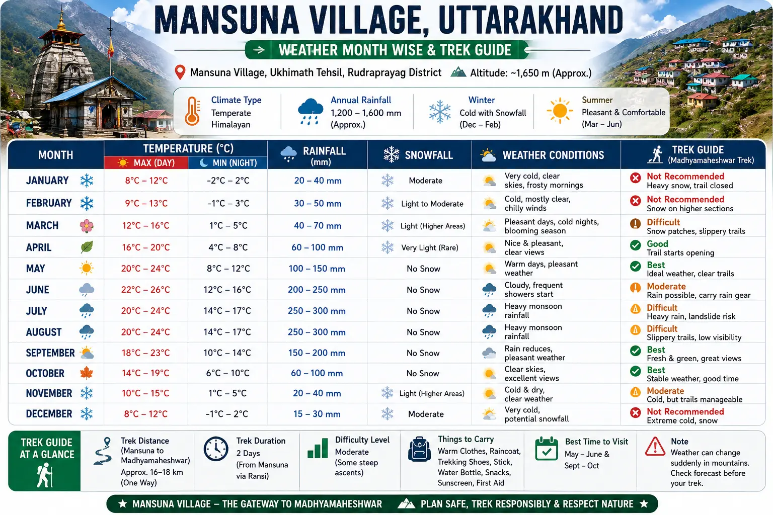
Mansuna Village Weather
Mansuna has a mountain climate, and weather conditions can change considerably between seasons.
The wider Uttarakhand region receives substantial monsoon rainfall. IMD's Uttarakhand monsoon reporting shows significant seasonal variation and confirms that June–September can bring substantial rainfall, including periods of heavy rainfall.
This matters because Mansuna is not simply a sightseeing destination where weather affects comfort. Rain can directly influence road safety and trekking conditions farther along the route.
Winter
Winter is cold, particularly at night.
Higher areas around the Madhyamaheshwar region can experience snowfall and severe winter conditions. The high-altitude temple's seasonal accessibility is therefore different from the lower settlement environment of Mansuna.
Spring
March and April generally provide a transition toward warmer daytime conditions, although mountain weather remains changeable.
This period can be attractive for travellers interested in forests, village landscapes and early-season mountain travel.
Summer
May and June are important travel months for pilgrimage activity.
Days can be pleasant at lower elevations, while conditions become substantially colder as elevation increases toward Madhyamaheshwar.
Monsoon
July and August require the greatest caution.
Rain can affect:
mountain roads
walking trails
streams
visibility
landslide-prone slopes
travel times
IMD data demonstrates that Uttarakhand's monsoon rainfall can be substantial and highly variable.
Autumn
September and October can offer clearer Himalayan conditions after the main monsoon period, although weather should still be checked before travel.
Late autumn and winter
Conditions become progressively colder, particularly toward higher elevations.
Best Time to Visit Mansuna
For travellers primarily interested in Mansuna Village, spring and post-monsoon autumn are generally the most practical periods to consider.
For travellers combining Mansuna with the Madhyamaheshwar pilgrimage or trek, the temple's seasonal opening and local trail conditions become more important.
Uttarakhand Tourism currently describes Madhyamaheshwar's principal season as roughly May to September in its destination information, while also explaining the temple's high-altitude environment.
Best periods by objective
Objective | Preferred period |
|---|---|
Village exploration | Spring / autumn |
Photography | Clearer spring or autumn days |
Madhyamaheshwar pilgrimage | Main temple season |
Green landscapes | Early monsoon, with significant weather caution |
Avoiding heavy monsoon risk | Generally avoid peak monsoon |
Winter village experience | Possible with preparation, but conditions can be harsh |
Always verify the current temple calendar and road status rather than relying on an old travel blog.
Mansuna Village Weather: Month-by-Month Guide
Month | Typical travel character | Planning note |
|---|---|---|
January | Cold winter | Carry serious winter clothing |
February | Cold | Snow/cold possible at higher elevations |
March | Spring transition | Good for lower-elevation exploration |
April | Pleasant spring conditions | Strong option for village travel |
May | Pilgrimage season begins | Good overall travel period |
June | Warmer but increasingly wet | Monitor rainfall |
July | Peak monsoon influence | Road and landslide caution |
August | Wet season | Avoid unnecessary mountain travel |
September | Monsoon withdrawal | Conditions can improve |
October | Autumn | Strong photography/travel period |
November | Cooling rapidly | Prepare for cold |
December | Winter | Higher areas become difficult |
This is a seasonal planning guide, not a weather forecast. Actual conditions vary from year to year.
Mansuna Village Culture and Local Lifestyle
Mansuna is a rural Garhwal Himalayan settlement rather than a resort destination.
That means visitors should expect local life to revolve around:
agriculture
household work
livestock
seasonal migration patterns
local religious practices
village relationships
schools and basic services
mountain roads
traditional food
forest and natural resources
The Census-derived land-use information records agricultural land, forest area, grazing land and other rural land categories, reinforcing the predominantly rural character of the settlement.
Visitors should remember that a village is a living community, not an open-air tourist attraction.
Photography should therefore be respectful. Ask before photographing people, homes, ceremonies or private property.
Traditional Houses
Traditional Himalayan architecture varies across Garhwal depending on geography, available materials, climate and household resources.
In villages around the Ukhimath region, travellers may encounter:
stone construction
masonry walls
sloping roofs
terraces
balconies
agricultural storage areas
newer concrete houses alongside older structures
Do not assume every traditional-looking building is historic.
A house can reflect local architectural traditions without being an officially protected heritage structure.
Agriculture in Mansuna
Agriculture remains an important part of the rural Himalayan economy.
Census-derived records list paddy among the agricultural commodities associated with Mansuna and report substantial unirrigated cultivated area.
Mountain agriculture is shaped by:
slope
altitude
water availability
rainfall
terrace construction
seasonal labour
livestock
For travellers, terraced fields are one of the most visually distinctive aspects of the landscape.
Visitors should stay on roads and established paths rather than walking through cultivated fields.
Food in and Around Mansuna
Do not expect the range of restaurants available in Rishikesh, Rudraprayag or larger tourist towns.
Food availability in a small Himalayan village can be seasonal and dependent on individual homestays or local establishments.
Typical Garhwali food in the broader region may include:
dal
rice
roti
seasonal vegetables
local pulses
aloo-based dishes
leafy vegetables
traditional chutneys
tea
simple breakfast preparations
If staying in a homestay, ask in advance what meals are available.
A simple local meal is often a more useful cultural experience than expecting a restaurant-style menu.
Mansuna Village Homestay and Accommodation
Accommodation availability in Mansuna is developing but remains much more limited than in larger destinations.
Current online listings show properties marketed specifically around Mansuna, including homestays and guest houses. For example, current booking listings include Panwar Home Stay Mansuna and Dakshu Guest House, while other accommodation listings appear along the Ukhimath-Mansuna Road.
Availability should always be verified directly before travel because small mountain properties can have seasonal operating schedules.
Where should you stay?
Stay in Mansuna if:
you want a village experience
you are comfortable with basic facilities
you want to support local accommodation
your route makes Mansuna convenient
Stay in Ukhimath if:
you need more accommodation choices
you want easier access to shops and services
you need a more predictable transport base
you are travelling with family or first-time visitors
Current accommodation listings also show multiple properties along the Ukhimath-Mansuna Road, confirming that the corridor has a growing visitor economy.
Mobile Network and Internet
Do not assume uninterrupted mobile connectivity in Mansuna or along the route beyond it.
Mountain geography can produce:
weak signals
dead zones
intermittent data
network differences between operators
If reliable connectivity matters for work or safety:
Download offline maps.
Save accommodation details offline.
Keep emergency contacts written down.
Inform someone about your itinerary.
Do not depend entirely on mobile internet.
Network availability can change with infrastructure upgrades, weather and location.
Electricity and Essential Facilities
Census-era records indicate domestic electricity availability in Mansuna, but those records should not be interpreted as a guarantee of uninterrupted modern power service today.
For a village stay, expect the possibility of:
voltage fluctuations
occasional power interruptions
limited charging options
fewer backup facilities than in larger towns
Carry:
power bank
charging cable
offline documents
flashlight/headlamp
Nearby Villages
The wider Ukhimath-Mansuna-Madhyamaheshwar landscape includes a network of small settlements.
The Census records villages such as:
Kunjalpur
Mansuna
Biroli
Burua
Giriya
Gaundar
Ransi Tarsali
Uniyara
within the same broader administrative village sequence.
Not all of these should be presented as “tourist attractions.” Many are working rural communities.
Mansuna's most important travel relationships
Ukhimath:
The nearest major service and pilgrimage centre in this immediate context.
Ransi:
A major reference point for the Madhyamaheshwar trek.
Gaundar:
An important settlement farther along the trekking corridor.
Bantoli:
A well-known stop on the Madhyamaheshwar trekking route.
Nearby Temples and Attractions
Omkareshwar Temple, Ukhimath
Ukhimath is one of the most important nearby religious destinations.
Uttarakhand Tourism identifies Omkareshwar Temple in Ukhimath as an important winter seat associated with Lord Kedarnath. During winter, the symbolic representation of Lord Shiva associated with Kedarnath is brought to Ukhimath for worship.
This makes Ukhimath particularly relevant to travellers combining Mansuna with a wider pilgrimage itinerary.
Madhyamaheshwar Temple
The main religious attraction connected with the Mansuna region is Madhyamaheshwar Temple.
Uttarakhand Tourism identifies it as a Panch Kedar shrine and describes the surrounding Himalayan landscape, including views toward major peaks.
Budha Madhyamaheshwar
Budha Madhyamaheshwar lies approximately 2 km from Madhyamaheshwar Temple according to Uttarakhand Tourism.
It is known for its panoramic mountain views, including peaks such as Kedarnath, Neelkanth and Trishul.
This belongs primarily in the dedicated Madhyamaheshwar trekking content cluster rather than being treated as a Mansuna village attraction.
Kalimath
Kalimath is another important religious destination in the broader Ukhimath region and can be incorporated into a wider pilgrimage itinerary.
The exact route and travel time should be checked using current maps.
Things to Do in Mansuna
Mansuna is not primarily an activity-packed tourist destination.
The strongest experiences are slower and more landscape-oriented.
1. Explore the village landscape
Walk through permitted public areas and observe:
terraced fields
mountain houses
forest edges
local roads
agricultural activity
2. Experience village life
If staying in a homestay, learn about:
local food
farming
seasonal routines
regional traditions
3. Use Mansuna as a regional base
Mansuna can work as a stopping point while exploring the Ukhimath-Madhyamaheshwar side of Rudraprayag.
4. Photograph the landscape
Morning and late afternoon can provide attractive light across the Himalayan terrain.
5. Continue toward the Madhyamaheshwar corridor
For trekkers, Mansuna is geographically relevant to the route toward Ransi and the higher settlements.
Do not turn this into an unsupported claim that Mansuna itself is the official trek starting point. Current Uttarakhand Tourism information identifies Ransi as the base camp and Uniana as the trek access point in its published route information.
Photography Spots
Good photography subjects include:
terraced agriculture
mountain ridgelines
village architecture
forested slopes
sunrise and sunset landscapes
rural roads
seasonal vegetation
distant Himalayan peaks where visible
Photography etiquette
Always avoid:
photographing people without consent
entering private homes
entering agricultural land
blocking roads
disturbing religious ceremonies
flying drones without checking applicable rules
The best village photography often comes from observation rather than staged interaction.
Flora and Fauna
The wider Rudraprayag and Garhwal Himalayan region contains diverse forest ecosystems.
The broader Kedarnath Wildlife Sanctuary landscape includes coniferous, sub-alpine and alpine environments and supports species such as Himalayan musk deer, leopard, barking deer and other Himalayan wildlife.
However, travellers should not automatically claim that every species found in the sanctuary occurs inside Mansuna village.
A responsible article distinguishes between:
Regional biodiversity and species actually observed within Mansuna.
For visitors, the most realistic wildlife experiences are usually birds, insects, butterflies and signs of small mammals rather than guaranteed sightings of large animals.
Never feed wildlife.
Packing Checklist
Item | Importance |
|---|---|
Government ID | Essential |
Cash | Highly recommended |
Power bank | Recommended |
Offline maps | Essential |
Comfortable shoes | Essential |
Warm layer | Essential |
Rain jacket | Seasonal but strongly recommended |
Headlamp | Recommended |
Water bottle | Essential |
Personal medicines | Essential |
Basic first-aid kit | Recommended |
Sunscreen | Recommended |
Sunglasses | Recommended |
Reusable bag | Recommended |
Torch | Recommended |
Waterproof phone pouch | Useful |
Small backpack | Useful |
For a Madhyamaheshwar trek beyond Mansuna, the packing list should be substantially more comprehensive.
Who Should Visit Mansuna?
Mansuna is particularly suitable for:
Pilgrims
Especially those visiting Madhyamaheshwar and the wider Panch Kedar region.
Trekkers
Those using the village as part of a wider Madhyamaheshwar journey.
Photographers
The village and surrounding terrain provide opportunities for landscape and rural photography.
Slow travellers
Visitors interested in local life rather than commercial sightseeing.
Researchers
Those studying Himalayan settlements, agriculture, tourism development or religious geography.
Nature lovers
Those interested in mountain landscapes and regional biodiversity.
It is less suitable for travellers expecting nightlife, shopping centres, luxury resorts or extensive public transport.
Frequently Asked Questions
Where is Mansuna Village?
Mansuna Village is in Ukhimath Sub-district of Rudraprayag district, Uttarakhand. Its Census village code is 042124 and its PIN code is 246469.
What is Mansuna Village famous for?
Mansuna is best known online for its geographical and travel connection with the Madhyamaheshwar region and the Panch Kedar pilgrimage route.
Is Madhyamaheshwar Temple in Mansuna Village?
Mansuna is closely associated with the wider Madhyamaheshwar region, but the village centre and Madhyamaheshwar Temple are separate locations. Travellers should therefore treat Mansuna as part of the approach region rather than assuming the temple itself is located inside the main village settlement.
What is the population of Mansuna Village?
According to Census 2011, Mansuna had a population of 888 people living in 189 households.
What is the height of Mansuna Village?
There is no single authoritative government-published village elevation identified in the sources reviewed. A topographic dataset gives Mansuna an average elevation of approximately 1,653 metres, while 3,497 metres is the commonly cited elevation of Madhyamaheshwar Temple.
How far is Mansuna from Ukhimath?
Mansuna is approximately 7–8 km from Ukhimath, depending on the route and measurement method.
How far is Mansuna from Rudraprayag?
Census-derived records place Mansuna approximately 50 km from Rudraprayag, the district headquarters. Road distance can vary according to the route used.
How do you reach Mansuna Village?
The practical route is to travel toward Ukhimath and then continue by road toward Mansuna. A broader approach from Rishikesh is through Devprayag, Srinagar, Rudraprayag and Ukhimath.
Is Mansuna connected by road?
Yes. Mansuna is connected to the road network around Ukhimath, and government geological documentation refers specifically to the Okhimath-Mansuna-Ransi link road.
Can you stay in Mansuna?
Yes. Current online accommodation listings include homestays and guest houses in Mansuna, although availability should be verified before travelling.
What is the best time to visit Mansuna?
Spring and autumn are generally practical for village exploration. For Madhyamaheshwar pilgrims, the temple's seasonal opening, weather and road/trail conditions should determine the final travel dates. Uttarakhand Tourism identifies May–September as the principal Madhyamaheshwar travel period in its destination information.
Is Mansuna suitable for a family trip?
It can be, provided the itinerary is designed around mountain travel and basic rural infrastructure. Families should avoid overly ambitious trekking schedules and should confirm accommodation and road conditions beforehand.
Is Mansuna good for photography?
Yes. Terraced fields, mountain slopes, rural architecture, forests and changing Himalayan light provide strong landscape and village photography opportunities.
Is there mobile network in Mansuna?
Connectivity can vary by location and operator. Travellers should download maps and important information before travelling rather than depending entirely on mobile internet.
Is Mansuna a Panch Kedar temple?
No. Mansuna is a village. Madhyamaheshwar is the Panch Kedar shrine associated with this region.
Is Mansuna the starting point of the Madhyamaheshwar Trek?
Not in the strict sense. Current Uttarakhand Tourism information identifies Ransi as the base camp and Uniana as the place from which the trek begins in its published route information.
What villages are near Mansuna?
The wider Census village sequence includes settlements such as Kunjalpur, Biroli, Burua, Giriya, Gaundar and Ransi Tarsali.